[:en]
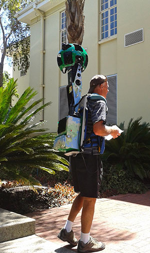
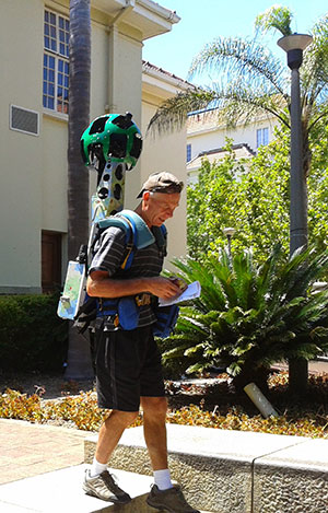
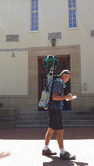
If you were still on campus from 17 to 19 December at the end of 2014, you might have seen someone walking around with an unusual device strapped to his back. This device is called the Google Trekker camera and is used to photograph the environment for Google Street View.
Thanks to a collaboration between IT, Facilities Management and Google, various locations on our own Stellenbosch campus have now been mapped and are available on Google Street View.
“Google Street View is a technology featured in Google Maps and Google Earth that provides panoramic views from positions along many streets in the world. It was launched in 2007 in several cities in the United States, and has since expanded to include cities and rural areas worldwide.
Google Street View displays panoramas of stitched images. Most photography is done by car, but some are done by trekker, tricycle, walking, boat, snowmobile, and underwater apparatus. A Trike (tricycle) was developed to record pedestrian routes including Stonehenge, and other UNESCO World Heritage sites.
In 2010 a snowmobile-based system captured the 2010 Winter Olympics sites. Trolleys have been used to shoot the insides of museums, and in Venice the narrow roads were photographed with backpack-mounted cameras, and canals were photographed from boats.”(www.wikipedia.org.za)
![]() On 8 March a mzansi experience was launched on Google Maps. Together with the launch, our university street view images were also made public. The images can be accessed on phone and desktop.
On 8 March a mzansi experience was launched on Google Maps. Together with the launch, our university street view images were also made public. The images can be accessed on phone and desktop.
Streets with Street View imagery available are shown as blue lines on Google Maps. When you hover over the mini-map in the left-hand corner, you will see where street map is available on campus.
You can now see the Rooi Plein, Botanical Gardens and Coetzenburg on Street View, as well as Jonkershoek. View the rest here and you can also click on the shortcuts at the bottom of your Street View to take you to various other locations on campus.
More on the Mzansi experience.
[:af]
As jy jouself in 2014 tussen 17 en 19 Desember op kampus bevind het, sou jy iemand toegerus met `n vreemde toestel opgemerk het. Die toestel is `n Google Trekker kamera en word gebruik om die omgewing te fotografeer vir Google Street View.
Te danke aan `n gesamentlike poging tussen IT, Fasiliteitsbestuur en Google oor die afgelope jaar, is verskeie areas op ons Stellenbosch-kampus ook nou karteer.
Google Street View is tegnologie in Google Maps en Google Earth wat panoramiese beelde van strate wêreldwyd verskaf. Dis in 2007 bekendgestel in verskeie Amerikaanse stede, maar is mettertyd uitgebrei na stede en plattelandse areas regoor die wêreld.
Street View vertoon `n panoramiese beeld deur middel van verskeie fotos wat aanmekaar gelas word. Die meeste fotografie word met `n motor uitgevoer, maar trekkers, driewielfietse, bote, sneeuvoertuie, onderwatertoestelle en voetslaan, word ook gebruik. `n Driewielfiets is ontwerp om staproetes, soos Stonehenge en ander UNESCO Wêreld Erfenis-areas, in te sluit.
In 2010 is `n stelsel monteer op `n sneeuvoertuig om die 201o Winter Olimpiese Spele se ruimtes te karteer. Trollies is gebruik om binne-in museums te fotografeer. Venesië se nou straatjies is afgeneem met `n kamera wat op `n rugsak monteer is en kanale is vanaf bote waargeneem. (www.wikipedia.org.za)
![]() Op 8 Maart is die Mzansi experience op Google Maps bekendgestel. Terselfdertyd is ons Street View fotos ook gelaai. Jy kan die fotos op jou rekenaar of slimfoon kyk.
Op 8 Maart is die Mzansi experience op Google Maps bekendgestel. Terselfdertyd is ons Street View fotos ook gelaai. Jy kan die fotos op jou rekenaar of slimfoon kyk.
Strate wat deel uitmaak van die Street View-projek word deurlopend met blou lyne op Google Maps aangedui. As jy die muis hou oor die mini-kaart in die linkerkantse hoek, sal jy ook sien watter areas op kampus beskikbaar is.
Jy kan nou, onder andere, die Rooi Plein, Botaniese Tuin en Coetzenburg, sowel as Jonkershoek, op Street View besigtig. Kyk gerus na die res hier en jy kan ook kliek op die kortpaaie onderaan jou Street View om na ander plekke op kampus te gaan.
Meer oor die Mzansi-ondervinding.
[:]

Tags: Google street view
Thank you Niven, I’ll pass your comment on to the team:)
Great Weldone !!!!!! thanks for this nice Iniciative I.T People
Stellenbosch campus available on Google streetview