Africa Imagined | Africa Explored : a selection of maps from the Hugh Solomon Collection is the result of a special book project by the Library and Information Service and the Department of Visual Arts, of Stellenbosch University. The book was inspired by the Hugh Solomon historical Africana map collection of the Library and celebrates the research value as well as the aesthetic beauty of these maps. The book also places the collection within the wider context of the history of cartography.
The book contains information about the Hugh Solomon map collection on which it is based, as well as two essays on early cartography and different mapping systems respectively, which form the first part of the work. The second part contains detailed images and descriptions of a selection of 20 important maps from the collection, as well as an image catalogue of the entire collection.
The valuable Hugh Solomon map collection is housed in the Africana section of Stellenbosch University Library and forms part of the greater Hugh Solomon Collection which was donated to the Library in 1958, consisting of works mainly related to early European accounts of travel to Africa. The map collection, which comprises 97 maps of Africa dating from before 1860, has also been digitized and is available on the Library’s digital heritage repository at http://digital.lib.sun.ac.za/handle/10019.2/653.
The collection boasts several interesting and unique maps in excellent physical condition. The oldest map in the collection is Abraham Ortelius’s “Africae Tabula Nova Edita Antverpia”, dating from 1570. Importantly, the collection also features two irreplaceable manuscript maps of which no printed copies have been traced. These unidentified sea charts depict False Bay and the Cape of Good Hope in 1788 and 1726 respectively. Other significant maps in the collection include 19th century maps of smaller regions of South Africa which are of particular interest to scholars of South African and African history as they display considerable detail on contemporary boundaries and routes.
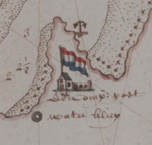
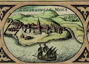
The two images below depict detail from two of the maps.
Africa Imagined | Africa Explored : a selection of maps from the Hugh Solomon Collection was compiled by Keith Dietrich, Elri Liebenberg and Mimi Seyffert, and published by Stellenbosch University in 2017. The book was designed by Keith Dietrich, Heléne van Aswegen and Neil le Roux. Heléne van Aswegen also printed and bound the book. The book was published in a limited edition of ten copies and is hand‐bound in pigskin leather.
Mimi Seyffert‐Wirth